Home GPS Download Business Partners Contact Family AVL Links History AsOnTV

Home GPS Download Business Partners Contact Family AVL Links History AsOnTV
 I've set up this page to provide information for both enthusiast
and business GPSS users who wish to try GPSS with street mapping created from that provided
by the GSI (Geographic Survey Institute of Japan) on
watchizu.gsi.go.jp/mapsearch.html
I'm most grateful to Hideo Ito in Japan for making me aware of this source of publicly downloadable mapping covering all Japan. I would also like to thank Nathan Giard and others for their help in testing.
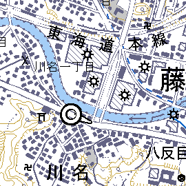
 The picture on the right is
© GSI, Japan 2003-2005
and should not be reproduced without the permission of both GSI and Sunninghill Systems.
Those wishing to try GPSS with this mapping should:
Robin Lovelock, Sunninghill UK, September 2005.
I understand that it is OK to download, convert, and use the mapping, but not to redistribute it. That is why I have not provided it as downloads from www.gpss.co.uk. Please see www.gsi.go.jp/LAW/2930/flow1.pdf This is in Japanese but I understand that it says: ... As long as "personal use without any re-distribution". everyone can freely use the mapping data on which is publicly disclosed/distributed from the Institute on an "as-is" basis. In this case, "a source" shall be shown (like the samples shown in the "blue Japanese characters (sentences)" in the yellow box.
I run under Windows XP Home, but I guess the following would be similar for all of you.
Visit watchizu.gsi.go.jp/mapsearch.html, and a map of Japan will appear, showing lines of lat/lon and how the mapping is broken into smaller areas.
click on the area of Japan you are interested in (e.g. Tokyo) and that smaller area map will appear.
e.g. the area "5339" on
watchizu.gsi.go.jp/indexmap200k/5339.html,
Click on the particular street map you want
e.g. the street map "53392555" on
watchizu.gsi.go.jp/watchizu.aspx?id=53392555,
Note that the map names are based on latitude and longitude - which makes addition to GPSS much easier.
Right mouse click on the displayed street map, choose "Save Picture As",
leave the name of 53392555 unchanged
choose type as "Bitmap (.BMP)"
choose a suitable folder such as c:\gpss where you have GPSS files
and save the file here as 53392555.BMP
 IMPORTANT: you may have to use the edge controls on the GSI street map to move to maps
either side and save these also. After downloading a batch of BMP maps, and running JAPMAP
to create the DES files, you may wish to stay online while you do a quick run of GPSS to
plot the coverage of these maps using `showmaps, on a bigger area JAPAN.EXE GPSS map,
since there may be gaps in coverage - and you may need to download some more BMP files.
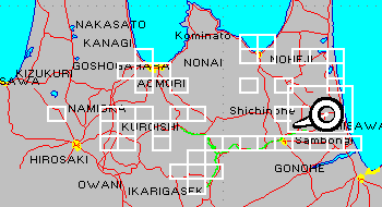
The `showmaps command should show you the coverage of the BMP maps like that on the right.
You may now exit your browser.
If you double click on this BMP file, Windows will display it (e.g. with "Windows Picture and Fax Viewer").
If you look at the properties you will see it is 2283 x 2000 pixels.
It will probably be rather large. e.g. 13 MB. At this stage you may wish to reduce the size down to more typically 2 MB by reducing the number of colours - maybe as low as 16. This can be done with the picture editor, or an image processing package such as Paintshop Pro (PSP) or Graphic Workshop (GWS). However, I sugggest your first tests are done with unmodified BMP files - less easy to make mistakes.
You are now ready to make the DES file, so that GPSS can treat the BMP file as a map.
You can save yourself the detailed work of making the DES and CPR files explained further below by use of the JAPMAP.EXE program.
You can download JAPMAP1.EXE from
www.gpss.co.uk/japmap1.exe
JAPMAP1.EXE self-extracts into JAPMAP.EXE, JAPMAP.TXT and NATHAN1.NME
These files should be put in the GPSS folder, with any BMP files from above.
JAPMAP searches for all BMP files that are these Japanese maps (all 8 characters must be numerics 0 to 9) and creates the required DES and CPR files.
JAPMAP now makes the required correction (typically 400 metres) by converting the Tokyo datum lat/lons into WGS84 lat/lons used by GPSS. The file JAPMAP.TXT can be used to add further corrections if needed. Documentation is within the JAPMAP.TXT file.
If you decide to run JAPMAP with the BMP files in a different folder, you will need to copy VBRUN200.DLL from the GPSS folder into this JAPMAP folder. All the BMP,DES,CPR files must be copied to the GPSS folder for GPSS to use them.
The copyright message file is to remind yourself, and anyone using GPSS, where this mapping came from:
!GPSS map based on mapping from watchizu.gsi.go.jp
not for distribution: see www.gsi.go.jp/LAW/2930/flow1.pdf
only for use with GPSS from www.gpss.co.uk
c GSI, Japan 2003-2005
The ! at the start tells GPSS to draw the message black so it can be seen on a white map.
DES files tell GPSS information such as the geographic coverage of the BMP file and the format of DES files is explained on the addmaps page. Here is 53392555.DES as an example with contents:
53392555 from GSI
53392555
LL, 2283, 2000
35.54167 139.68750, 0, 1999
35.58334 139.75000, 2282, 0
JAPAN.WAW
This section documents Robin's understanding of the relationship between BMP file name and lat/lon which needed to be included in JAPMAP. It is included here to help you help Robin find mistakes - if any remain :-)
Each of these street maps is 2.5 minutes of latiude north south and 3.75 minutes of longitude east west. So if we know the south west corner lat/lon we can just add these values to get the north east corner.
The south west corner lat/lon is provided by the first 6 characters of the map name as follows:
53392555 is the map name, and first 6 characters are 533925
For latitude use characters 1,2 and 5 as follows:
latitude = (53/3)*2 degrees = 35 1/3 degrees or (because there are 60 minutes in a degree) 35 degs 20 mins.
then add 5th character 2 x 5 minutes = 10 minutes ---> 35 degs 30 minutes.
then add 7th character/10 * 5 minutes.
For the longitude, use characters 3,4,6 and 8 as follows:
longitude = 100 + 39 = 139 degrees.
then add 3.75 minutes x 6th character.
then add 8th character/10 * 7.5 minutes.
The north east corner is found by adding the 2.5 minutes N and the 3.75 minutes E.
1 degree = 60 minutes, so if you divide all those minutes by 60
you should get the same answer as JAPMAP - almost.
Unfortunately the data from the GSI site is using the Tokyo Datum for lat/lon which differs from WGS84 lat/lon used by GPSS by several hundred metres. The required conversion between these datums is now done within JAPMAP.EXE - so you will see slightly different values in the DES files.
The next time you start GPSS it should see the DES file and add this map to MAPS.DIR so it will be used automatically if you go into the area with your GPS working, or if you use the information on testing other maps on the tips page.


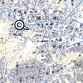
GPSS fits the whole BMP image to the screen, so this simple method of adding a map based on the whole BMP file will work, but appear as on the left. i.e. it will not show the full detail in the image, as you see on the right (unless your PC screen has a VERY high resolution).
You will see the full detail, as on the right, if you use the Ctrl-Z key to toggle off the GPSS action of zooming the BMP image to fit the screen - but you will not see all the map.
These sample images are © GSI, Japan 2003-2005 and should not be reproduced without permission of both GSI and Sunninghill Systems.
One solution of providing the detailed mapping over the whole area might involve breaking the 2283 x 2000 pixel BMP file into 9 or more overlapping BMP file - each with their own DES and CPR file. This is something better done by software, such as a future JAPMAP.EXE utility.
However, GPSS.EXE has been changed, so you can see the full detail without change to the BMP file.
You may wish to try the latest pre-release version of GPSS.EXE on the oldnew page.
The first version switches on an automatic pan using Cntrl-S and shows the full detail.
After bugs are removed, and other changes made, this will all happen automatically, without the need for Cntrl-S key use. i.e. GPSS will use this feature if it sees that the BMP size is larger than the screen resolution.
© 1991-2005 Robin Lovelock, Sunninghill Systems.
Robin Lovelock, Sunninghill Systems, 22 Armitage Court, Sunninghill, Ascot, Berks SL5 9TA, United Kingdom.
Sunninghill Systems International Limited and Sunninghill Software Limited are registered at the above address.