Home GPS Download Business Partners Contact Family AVL Links History AsOnTV
Home GPS Download Business Partners Contact Family AVL Links History AsOnTV
 Hi ! This page is for those helping me test ARED with the Microsoft
CDs below. I'm extremely gratefull to Microsoft, for their
supply of CDs, advice and cooperation, and all those who helped test
ARED with the 2000 CDs, then 2001, 2002, 2003, 2004, and now the 2005 products.
ARED seems to have worked well with these Microsoft CDs over the
past few years. Much of the information below
is old but I hope it will still be useful.
I've tried to retain compatability with the old Microsoft CD products,
despite changes such as user interface and map scales.
Hi ! This page is for those helping me test ARED with the Microsoft
CDs below. I'm extremely gratefull to Microsoft, for their
supply of CDs, advice and cooperation, and all those who helped test
ARED with the 2000 CDs, then 2001, 2002, 2003, 2004, and now the 2005 products.
ARED seems to have worked well with these Microsoft CDs over the
past few years. Much of the information below
is old but I hope it will still be useful.
I've tried to retain compatability with the old Microsoft CD products,
despite changes such as user interface and map scales.
ARED is not yet suitable for the "naive user" but has already been invaluable to a few businesses, or those who do not mind "getting down to the metal" when using ARED with a new release of Microsoft AutoRoute or Trips :-) Maybe in the future we will be able to make it more user-friendly, and maybe there will be a closer relationship with Microsoft and these products in the future. e.g. import of the planned route to provide turn-by-turn guidance within GPSS.
One of the reasons that ARED has been in a continual state of change is the fact that there are often subtle differences each year in each release of Microsoft CD. Keystrokes for a particular function, such as selection of map location, may be different between different languages (e.g. English, German, French, Italian). Map scales may vary - hence the recent introduction of "fiddle factor" controls, to support experiments to find the right factors (implemented automatically by later releases of ARED). Scaling sometimes varies with what display resolution the PC is set to (e.g. 640x480, 800x600, 1024x768). Hence there are many combinations to test ! :-)
Over the years Microsoft have produced several CDs, sold at typically 25$US to 50 GBP:
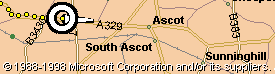
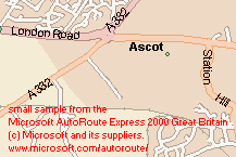
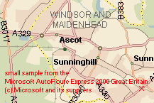
The image on the left shows the typical detail available in the mapping on the Europe
Version. This detail covers all Europe, including
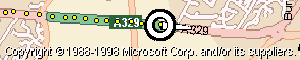 UK and Russia, past Moscow, to the Urals.
The image on the right is from the GB Version, which covers
all the UK mainland (England, Scotland, Wales).
UK and Russia, past Moscow, to the Urals.
The image on the right is from the GB Version, which covers
all the UK mainland (England, Scotland, Wales).
For more information on
Copyright, Licence Conditions, and Legal Aspects, see below.
Most of the information in later sections of this page, have not been updated, but remain largely true. e.g. licence and legal aspects seem the same, and tips on testing still apply. There are now extra "2001", "2002", etc radio buttons near "Autoroute" and "Trips" on ARED to select the Microsoft CD. This sets up changes, needed for differences between the various CDs. e.g. emulated keystrokes for entry of latitude/longitude, map scales, etc.
Those in USA should click on "USA Trips" button ( followed by "2001" if using 2001 rather than 2000). Those using the GB product should click "AutoRoute" (then "2001" or "2002").
You should get a "green light" when you have selected the correct CD. i.e. titles match and ARED can communicate with the Microsoft CD with the correct sequences of emulated keystrokes.
ARED is for use by those using GPSS, who also have AutoRoute or Streets & Trips 2000. ARED automatically generates a cache of GPSS-compatible maps, as BMP, DES and CPR files, for a specified area. These are then automatically recognised and used by GPSS.
ARED works by automating the process that can already be done manually by an AutoRoute and GPSS User. i.e. running AutoRoute, selecting a map scale and location by entry of a lat/lon, exporting the map image to the Windows Clipboard, then saving this as a BMP file, for calibration with GPSS. But instead of each map taking several minutes 'manually' (with plenty of scope to make mistakes), the automatic process takes a few seconds per map. So the ARED user can ask for a pattern of perhaps 3x3, 9x9 or even 99x99 maps of a particular scale.
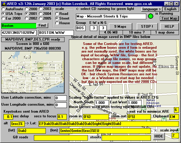
The picture below shows the ARED form after clicking on AutoRoute then 2004 radio
buttons while running AutoRoute 2004.
ARED includes a 'Find' button which searches
any GPSS WAW files for a place, then automatically sets up default
parameters including lat/lon centre and map coverage pattern.
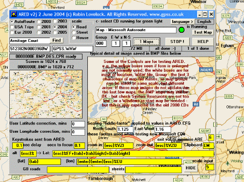
Here is what ARED looks like, after clicking on [USA Trips], [2001] to get the green light, then [Street] to select street level scale, then "bos" [FIND] to find Boston (in the WAW files and automatically set up the controls) then [Test Map]. Clicking [9 Maps] would make 9 maps covering all Boston.
ARED still requires minor changes, to make it more user-friendly, extend the range
of languages* and map scales it can handle, and ensure it is reliable and bug free.
Robin is therefore looking for 'Beta-Testers' already familiar with GPSS, including
use 'for real' with a GPS and adding their own maps - and have one of
the three AutoRoute CDROMs.
* the language CHANGE button - different keystrokes for non-English Windows !
The minimum requirement for these 'Beta-Testers' is that they have established a direct technical relationship with Robin, having followed steps 1, 2, and 3 on the download.htm page. They must have convinced Robin that they can use GPSS 'for real' with a GPS connected to their Laptop PC, and that they have a legal copy of one of the Microsoft CDROMs.
These people will be provided with support, key codes, etc.
Here are the steps for those helping Robin with ARED testing:
* Non-English ARE installations have differences that need to be setup. e.g. the title "Europe" may be "Europa". In German, the yellow box (revealed if ARED form is maximised) with IL should be changed to SL, and EM to BP. These are now automatic, by use of the language "change" button and/or ARED.CFG. PLEASE NOTE THAT ALL LANGUAGES MAY NOT YET BE AUTOMATIC.
Robin is getting good results, running AutoRoute or Trips in English, at screen resolutions of 640x480, 800x600 and 1024x768. Robin is grateful to those helping test ARED in UK, Germany, Italy, Holland and USA.
If in doubt - CONTACT ROBIN.
Here are a few tips:
YOU USE THIS SOFTWARE ENTIRELY AT YOUR OWN RISK.
ARED is for use by legal owners of the Microsoft CDROM(s) and GPSS.
You should have registered GPSS with Robin, via the Quiz on the download page.
Copy ARED2K.EXE into same diectory as GPSS.EXE, then run ARED2K.EXE from DOS or Windows to self-extract the ARED files, including ARED.EXE - which should be run from Windows. Please read any Help messages displayed by ARED. You may need to use those "fiddle factor" controls - Robin thanks Alan Redman in UK for finding AR 2004 fiddle factor values, now in v2k.
Here is the old tested version, for those who used ARED in past year or so.
Please help us test this new ARED with AutoRoute and Trips, and for all the possible combinations of display resolution. Testing of these maps are best done useing Control-A plotting of a NME file recorded with GPSS % key while taking a "run around the block". i.e. indoors without the GPS, rather than outside burning all that gas :-)
The text below has not changed in years. I apologise now for the technical inacuracies, but I believe the legal aspects still hold true.
We understand that all mapping on the Europe Version is the copyright of AND Mapping, based in the Netherlands. Mapping on the GB Version seems to be based on the Ordnance Survey 1:50,000 Meridian product, with changes and additions, such as street names, provided by NavTech and/or Microsoft.
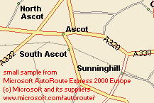
The small extracts at the top of this page, are from the same Ascot area of UK, in GPSS ASCOT.BMP - copyright permission already obtained from Ordnance Survey.
Senior staff within both Microsoft and AND have been consulted to ensure there are no objections in this use of the CDROM products and contained mapping. Microsoft have also be asked for clarification on 'grey areas' of the Licence Conditions.
Examination of the Licences issued with AutoRoute 2000 CDROMs seem to indicate that such use of the CDROMs, with ARED and GPSS, are not in breach of the licence conditions: ARED simply automates what is already available to the user.
However, the reader is advised to confirm this himself, by reading the licence text, and taking legal advice if required. There are certainly 'grey areas' that might need clarification. e.g. suppose a user owned a legal copy of Autoroute 2000 (only capable of being run under Windows 95, 98 or NT) but wished to move the 'cache' of maps, from his desktop PC, via a CDROM writer, onto a Laptop running GPSS under Windows 3.11 ? (GPSS has less restrictions on which Operating System it runs, and the minimum ammount of RAM, etc). e.g. Some businesses might wish to sell bundles of AutoRoute-ARED-GPSS, simply by bulk-buying the AutoRoute CDROMs and Licences (although it would seem more appropriate to negotiate 'the right deal' with Microsoft or a mapping supplier such as AND or Ordnance Survey).
However, it seems that in the simple case where the user has installed Autoroute, ARED and GPSS onto his Laptop PC, any use as described here is OK. If we obtain more clarification on this, we will update this page.
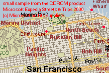
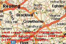
 The following small, credited samples, are fragments of screen image appearing
on the PC screen when running one of the three Microsoft CDROM products.
These same sample 217x145 pixel images are bundled into the ARED package,
to provide user feedback to use of CDROM selection and scale buttons.
The following small, credited samples, are fragments of screen image appearing
on the PC screen when running one of the three Microsoft CDROM products.
These same sample 217x145 pixel images are bundled into the ARED package,
to provide user feedback to use of CDROM selection and scale buttons.
In the event that a sample is not available, a default image is displayed, based upon Ordnance Survey 1:50,000 raster product, bundled into the GPSS baseline as ASCOT.BMP and UK Crown Copyright. Permission for use of this sample was obtained from UK Ordnance Survey over 5 years ago, when GPSS was first released.
 Microsoft have been consulted on use of these small samples, and we understand
that Microsoft and their relevant suppliers have no objection to their use here.
Microsoft have been consulted on use of these small samples, and we understand
that Microsoft and their relevant suppliers have no objection to their use here.
ARED currently only supports two scales of mapping, for each of the three CDROM products (although it can be extended to other scales by use of ARED.CFG).
 The top left sample is from the GB product at street level, and road level is on the right.
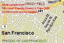
The next two samples are from the USA product, and the last two samples are from the
Europe product, which we understand is entirely based on AND copyright mapping.
The top left sample is from the GB product at street level, and road level is on the right.
The next two samples are from the USA product, and the last two samples are from the
Europe product, which we understand is entirely based on AND copyright mapping.